District Profile
From Wikipedia, the free encyclopedia.
This article is about the district. For its eponymous headquarters, see Pakur.
District of Jharkhand
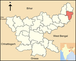
Location of Pakur district in Jharkhand
Country : India
State : Jharkhand
Division : Santhal Pargana division
Headquarters : Pakur
Government
Lok Sabha Constituencies Rajmahal (shared with Sahebganj district)
Vidhan Sabha constituencies 3
Area Total : 1,805.59 km2 (697.14 sq mi)
Population (2011)
Total 900,422
Density 500/km2 (1,300/sq mi)
Urban 5.13%
Demographics
Literacy
50.17 per cent
Sex ratio 989
Time zone : UTC+05:30 (IST)
Website http://pakur.nic.in/
Pakur district is one of the twenty-four districts of Jharkhand state, India, and Pakur is the administrative headquarters of this district. Pakur sub-division of Sahibganj district was carved out on 28 January 1994 to constitute Pakur District. The district, with a population of 900,422 (census 2011), and covering an area of 686.21 km⊃2;, is situated on the north-eastern corner of Jharkhand state. The district is bounded on the north by Sahibganj district, on the south by Dumka district, on the west by Godda district, and on the east by the Murshidabad district of West Bengal.[1]
Contents
- Economy
- Administration
- 1Blocks/Mandals
- Demographics
- See also
- References
- External links
Economy
It is famous across the world for its Black stone. It supplies nearly 500 Truck Stone chips daily to Bangladesh. It is generating the highest revenue for Howrah railway Division by supplying Black Stone Chips across India and Coal to Punjab.
Traditionally, Pakur has been the land of Santhals and Mal Paharia Adivasi people. However, over a period of time, demographic composition has gradually changed and the local folks have come to the mainstream of the Indian society.
In 2006 the Ministry of Panchayati Raj named Pakur one of the country's 250 most backward districts (out of a total of 640).[2] It is one of the 21 districts in Jharkhand currently receiving funds from the Backward Regions Grant Fund Programme (BRGF).[2]
Administration
Blocks/Mandals
Pakur district consists of six community development blocks. The following are the list of the blocks in the Pakur district:
- Pakur Block
- Maheshpur block
- Hiranpur block
- Littipara Block
- Amrapara block
- Pakuria block
Demographics
According to the 2011 census Pakur district has a population of 900,422,[3] roughly equal to the nation of Fiji[4] or the US state of Delaware.[5] This gives it a ranking of 465th in India (out of a total of 640).[3] The district has a population density of 498 inhabitants per square kilometre (1,290/sq mi) .[3] Its population growth rate over the decade 2001-2011 was 28.15%.[3] Pakur has a sex ratio of 985 females for every 1000 males,[3] and a literacy rate of 50.17%.[3]
At the time of the 2011 Census of India, 39.42% of the population in the district spoke Bengali, 36.40% Santali, 16.83% Hindi, 4.90% Malto and 1.77% Urdu as their first language.[6]
Historical population
| Year | Pop. | ±% p.a. |
|---|---|---|
| 1901 | 215,587 | — |
| 1911 | 224,304 | +0.40% |
| 1921 | 214,299 | −0.46% |
| 1931 | 244,945 | +1.35% |
| 1941 | 266,956 | +0.86% |
| 1951 | 277,421 | +0.39% |
| 1961 | 347,012 | +2.26% |
| 1971 | 403,078 | +1.51% |
| 1981 | 464,154 | +1.42% |
| 1991 | 564,253 | +1.97% |
| 2001 | 701,664 | +2.20% |
| 2011 | 900,422 | +2.53% |
References
- "Profile".
- Jump up to:a b Ministry of Panchayati Raj (8 September 2009). "A Note on the Backward Regions Grant Fund Programme" (PDF). National Institute of Rural Development. Archived from the original (PDF) on 5 April 2012. Retrieved 27 September 2011.
- Jump up to:a b c d e f "District Census 2011". Census2011.co.in. 2011. Retrieved 30 September 2011.
- US Directorate of Intelligence. "Country Comparison:Population". Retrieved 1 October 2011. Fiji 883,125 July 2011 est.
- "2010 Resident Population Data". U. S. Census Bureau. Retrieved 30 September 2011. Delaware 897,934
- 2011 Census of India, Population By Mother Tongue
- Decadal Variation In Population Since 1901
External links
- Official district government website
- Pakur District Population, Jharkhand - Census India 2011